Available courses

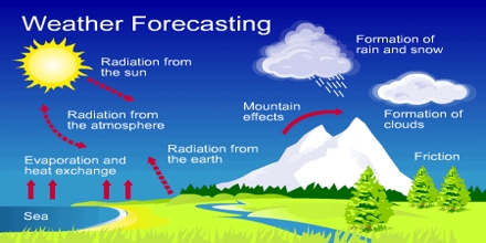
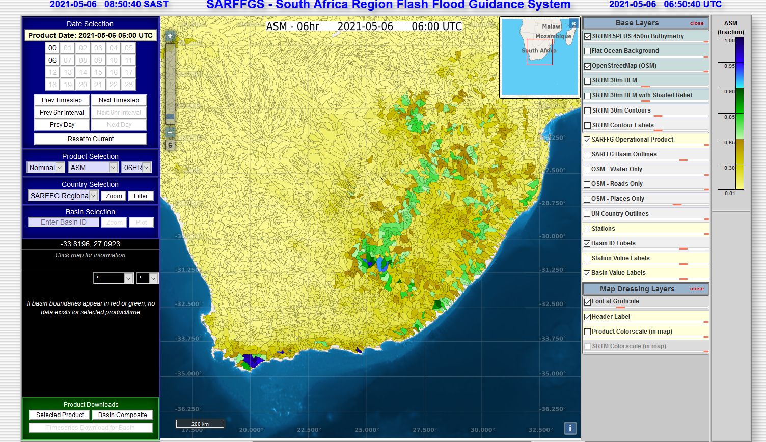
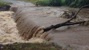
    This course focuses on the application and interpretation of severe weather alerts released by the South African Weather Service to Disaster Management structures

    This is a course where the basic aspects of weather are presented. modules will briefly deal with the most popular questions asked about the weather and weather forecasting.

    The 1-Day Basic Meteorological Understanding course is designed to facilitate an understanding of some basic meteorological concepts for persons without a background in meteorology.  It serves as background for understanding atmospheric processes and as well as the interpretation of weather systems in the Southern Hemisphere, and is regularly presented to new members of staff and key stakeholders.  Primarily, the course seeks to;

    • Promote a basic level of meteorological and climatological understanding
    • Promote an understanding of the different types of weather instruments and various weather data collection tools, as well as to
    • Improve the interpretation of SAWS products

    The course included presentations on the following areas of focus;

    • The structure and composition of the atmosphere
    • The characteristics of surface and upper air circulation
    • The classification of different cloud types and precipitation associated with them
    • Understand how the meteorological data information is collected, and how it is used in the compilation of a weather forecast, and
    • Interpretation of the weather forecast issued by the Weather Service.

    The WMO review of the BIP-MT course

    CoComm 2018

    Satellite image interpretation and the basics of satellite meteorology

    This is a "pre-course" online interface, where you can test your skills on the basics of MSG image interpretation. There will be data resources for you to work though, as well as quizzes which you will need to complete in order to be eligible to be formally invited to attend the workshop in Pretoria, South Africa in March 2015.

    The Eumetsat Satellite workshop aims to cover basic satellite image interpretation as well as to introduce new techniques in visualizing and manipulating satellite data. This years' course will be more practical and "hands on". the Online phase will run from the 13th October until the 19th November. The workshop itself will be hosted in Pretoria, South Africa, from the 1st to the 5th December 2014.  

    This is the online phase For the upcoming satellite workshop to be hosted in Pretoria in March 2016.

    An Introductory course on Coastal Meteorology aimed at those that seek to understand the characteristic nature of the coastal environment and its weather.  In order to bring about the optimal and harmonious use of this resource by the vast cross-section of users, there needs to be a sound understanding of it, and the basic meteorological and oceanographic processes that take place within it.

    The course will assist the participants in understanding;

    • circulation within the coastal ocean,
    • coastal atmospheric circulation (including the marine atmospheric boundary layer), as well as 
    • ocean-atmosphere interaction processes.

    It is hoped that at the end of this course, participants will have attained an enhanced knowledge & understanding of the coastal zone to support strategy and decision-making.  More specifically, participants are expected to gave gained:

    • An enhanced knowledge of meteorological processes specific to the coastal zone,
    • Improved understanding of the impact of meteorological events on the coastal zone

    A platform created for the WMO RA1 Marine Forecaster interaction and capacity building

    This forms part of the marine post interview

    This is a resource site where Meteorological Case studies can be uploaded from any operational personnel. The archive will be accessible to all interested and involved parties and can be updated with interesting weather related cases. Resource material can include (but is not limited to) satellite imagery, NWP output, RADAR imagery, Lightning detection information, photographs and real time observational data.

    Meteorological basics for industry

    This is a course focusing on the continuous training needs of the SAWS weather forecasters. the course contains material dealing with NWP, Satellite, Forecasting and Radar training.

    The course format includes online quizzes, tasks and discussion forums. All forecasters are welcome to partake in the course.

    This is a collection of conceptual models created by operational forecasters within SAWS.

    This course is aimed at testing your current satellite knowledge and being able to ask satellite meteorology-related questions. feel free to share interesting cases as well and help each other (and me) to learn.

    A forum to discuss interesting features seen on satellite imagery

    This is a Pre Assessment to identify possible knowledge gaps

    The course aims to provide training to operational forecasters on the interpretation of the Unified model output products

    Weather SMART training for weather SMART presenters

    It is the vision of the South African Weather Service to ensure 57 million WeatherSMART citizens. While being externally relevant is important, it is equally important that our staff are also WeatherSMART. For this reason, the RTC launched a “Weathersmart stuff for WeatherSMART staff” initiative.

    This course consists of quarterly, morning training sessions.

    The sessions will be covering basic meteorology, climatology, air quality and observations. 

    Each session will be followed by a questionnaire.

    These notes show the similarities and differences in the coding of METARs and SPECIs with those of MET TEPORTS and SPECIAL report formats

    This module explains the MetCap testing of sensors and the QC procedures

    This is a short course on small portion (Tropical Cyclones) of Tropical Meteorology

    The course content is based on the Information obtained from the new and updated WMO International Cloud Atlas

    Upper air data and coded messages

    This is a course for practice as a reviewer for WMO moodle course that is being developed.

    WMO/ICAO Aeronautical Meteorological Observer (AMO) Competency Criteria

    1. Monitor continuously the weather situation.

    2. Observe and record aeronautical meteorological phenomena and parameters.

    3. Ensure the quality of the performance of systems and of meteorological information.

    4. Communicate meteorological information to internal and external users.

    Guidance in the compilation of PoEs to prove competency against specified ICAO competency criteria.

    This module looks at the general and scientific definitions of temperature as used in Meteorology. We also look at different instuments used to measure temperature along with their means of operation, how the temperature varies in one day as well as its impacts on atmospheric stability.

    This should be read along with chapter three of explain basic meteorological concepts training manual for the National Certificate: Weather Observations. Any other material can also be used should there be a need for more knowledge not covered here and in the training manual. RTC trainers are also accessible for more explanation if necessary.

    Summary.pdfSummary.pdf

    A basic refresher module on the interpretation of wind roses for use by Meteorological Technicians.

    A brief online learning module on fog and mist

    A refresher training course for Meteorological Technicians on the topic of: atmospheric moisture indicators

    Interpretation of Tephigrams from an observation aspect

    This topic goes through the definition, formation, movement and weather impacts of a coastal low over the coast of South Africa.

    Cut-Off Lows form part of the main rain bearing weather systems which bring moderate or heavy rainfall over South Africa.

    This course is presented within the RTC Pretoria as part of the Post Graduate Certificate: Weather Forecasting

    It has 2 components: A Theory component (5 days) and a practical component  (6 months)

    The 5 specific outcomes of the Aeronautical Meteorological Forecasters (AMF) course are:

    1. Analyse and monitor continuously the weather situation.

    2. Forecast aeronautical meteorological phenomena and parameters.

    3. Warn of hazardous phenomena.

    4. Ensure the quality of meteorological information and services.

    5. Communicate meteorological information to internal and external users.

    This course is designed to empower those doing Aviation Forecasting


    The course deals with important theory behind the Aviation Meteorological Forecaster Competencies of WMO.  This theory lays the foundation for learning how to do the practical aviation meteorological forecast competencies


    The course will help to understand:-


    The underpinning aviation theory needed to perform the duty of an aviation weather forecaster.

    This page contains notices, information and news that is specific to the forecasting certificate course.

    Complete a forecasting based research project

    This is in-house training on the FFG

    The competence requirements for MWF are divided under the following categories


    1. Analyse and monitor continuously the marine weather situation
    2. Forecast marine weather phenomena, variables and parameters
    3. Warn of hazardous phenomena
    4. Ensure the quality of meteorological information and services
    5. Communicate meteorological information to internal and external users

    Interpret upper air ascent data (Tephi and Skew T)

    Decode and interpret surface observational weather data and integrate data with knowledge on Climate, Geography and topography of South Africa

    remote sensing for the Forecasting certificate students.

    Integrating and interpretation of all observational and remotely sensed data

    This course targets a primary audience of Meteorologists who would like to become competent Aviation Meteorological Forecasters (AMF).

    The course has 2 phases: A distance learning phase (4 months) and a classroom phase (1 month) where the practical competency for AMF is developed by forecasting and warning against hazardous weather phenomena using hazardous weather simulations.

    This course will focus on the Meteosat Second Generation (MSG) Satellite and its products. This satellite provides South Africa with the best Geo-Stationary satellite imagery available. The MSG system is established under cooperation between EUMETSAT and the European Space Agency (ESA), to ensure the continuity of meteorological observations from geostationary orbit. Software and data for the course will be obtained directly from Eumetsat. 
    
    The following concepts will be covered in the course:
    
    •	Basics of remote Sensing
    •	Introduction to all 12 Channels of the MSG satellite
    •	Introduction to Channel difference and Brightness Temperature Differences (BTD)
    •	Introduction to channel combinations (RGB)
    •	Basic cloud type identification
    •	Accessing Data
    •	Introduction to data manipulation using appropriate software

    This is the commercial AMF course for SADC delivered to: 

    Mozambique participants: Oct 2018

    Lesotho participants: Oct/Nov 2019

    Namibia participants: Oct 2019


    This course will focus on the basics of weather systems and terminology

    Learning resources for the meteorological training of members of the South African National Antarctic Expedition, Meteorological Teams

    Meteorological training for the Marion Island Expedition's overwintering team meteorologists.

    This is a training needs Survey for the 2022 WMO forecasting course

    This survey is aimed at gathering data on the operational use of the FFG products in the SAWS forecasting offices.

    A needs analysis survey to determine training needs for Public Weather Forecasters

    This is a survey to establish the regional forecasting training needs in the SADC region

    A needs analysis survey to determine training needs for Aviation Weather Forecasters

    This is a survey to determine stake holder satisfaction of the 2018 forecaster intake into operations 6 months after they were appointed

    This is a survey for the supervisors of the newly employed forecasters

    This survey is intended to plan the re-fresher training of the forecasters in Cape Town as the prepare to take on the marine operations in 2019. 

    This is a survey for the supervisors of the newly employed forecasters

    This is a survey to determine stake holder satisfaction of the 2017 forecaster intake into operations 6 months after they were appointed

    This is a survey to establish the regional forecasting training needs in the SADC region

    This course provides a brief introduction to the concepts of Total Quality Management


    Help with Search courses